The Bunurong People are Indigenous People from south-east Victoria, their traditional lands are from the Werribee River in the north-west, down to Wilson’s Promontory in the south-east, taking in the catchments of the old Carrum swamp, Tarwin River and Westernport Bay, and including Mornington Peninsula, French and Phillip Islands.
Bunurong People were part of a language group or nation known as Koolin. Bunurong People prefer to be described as Koolin or Bunurong rather than Koorie, which is a word from another Aboriginal language.
Point Nepean Statement of Significance
“Our Ancestors called this place Monmar. It has always been a sacred place and it always will be. It is one of the most sacred sites on the Peninsula, the traditional lands of the Burin’yong Bulluk, a clan of the Bunurong/Boon Wurrung.

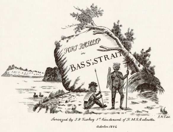
Detail from Lt James Tuckey’s chart of Port Phillip of 1804
Showing an early representation of the Bunurong
For thousands of years our people have met at Wonga (Arthurs Seat), the men would head to Cape Schanck and the women to Monmar, this is not to say that it is strictly a women’s site, but it is now predominantly known as such. There is a special women’s place here for birthing, women’s ceremony and initiation of the younger women.
Many of our community today are direct descendants of women taken against their will from the beaches of Point Nepean by Sealers. These women were tricked into approaching the sealers who once close enough, abducted them and took them to places like the Bass Strait Islands and even Western Australia.
This happened on more than one occasion and was well documented in the journals of early settlers to the area and was later published in many books that discussed the topic. One case saw six or more women (including young girls and a boy) taken at one time.
Several of these women were prominent women within the community, the wives of Bunurong/Boon Wurrung head clansmen Derrimut, Big Benbow, Betbenjee and Budgery Tom. Some of the abducted women’s names are recorded as Nan.der.goroke, Nay.nar.gorote, Nan.nat.gooruk, Nan.nert.goroke, Kar.ding.goroke, Tout.kun.in.grook, Doog.by.er.um.boroke and Toolom.
We can stand in the spot that these women were taken from and try to see what they saw. We can stand in the same water with our feet in the same sand and hear what they heard. We enjoy the natural sounds of the place and the chance to acknowledge the past respectfully and to walk where our ancestors walked.
If we look at the vegetation using our own knowledge, a clear ordered living pantry appears
across the landscape, linking areas. Our ancestors planted out these areas to provide for the needs of all; sometimes with food and others simply with flowers they enjoyed to see. Because some of the National Park has not been heavily disturbed by European activities we can see how the landscape was used and modified by our people. The whole region, from Point Nepean to the Sisters and Arthurs Seat to Cape Schanck, are all connected by a thousand generations worth of tradition, story and song.
The archaeological record shows too that men are also making, using and maintaining stone tools here. The stone tools were mostly being used for making wooden tools and the wooden tools were used to hunt food, or for defense. Many settlers noted seeing the large mobs of kangaroo’s that used to be at Point Nepean, a very good hunting spot indeed.
The coastline here contains layers and layers of burnt shell (kitchen middens) dating back to shortly after the bay flooded with water some 10,000+ years ago. Some of these layers have gaps of over 1000 years between them, where our people eventually sat directly over the same place again, over 1000 years later, to do the same thing, make fire, cook food, eat together and tell stories. From the small amount of archaeological work that has been done at Point Nepean we have already demonstrated that our ancestors have been here for at least 14,000 – 18,500 years.
One of the sites found is 1.2 meters deep and comprised of a subsurface stone artefact scatter that had once been deposited on the ground surface, near to the edge of a cliff, at a time when our people could look back over the bay to see a grassy plain with the Yarra River winding its way out to sea over a beautiful waterfall. Below the waterfall was a source for a sacred red stone that our ancestors quarried to make special stone tools. These tools were used for certain ceremonies or for making wooden tools to be used in ceremony, or sometimes for carving stories into these important objects. If you could see this stone you would understand why Bunurong/Boon Wurrung people traditionally believed it was the actual solidified remains of an ancient creator spirit.
One old mythology story speaks of the Mindie, a menacing creator spirit that came across the heads and onto the Peninsula during a terrible storm in the form of a whirlwind or willy willy. The Mindie travelled angrily up the Peninsula shaping the dune systems as it went. Water then filled the low points creating the waterholes that were so important to life in this area.
We believe our people have been walking this cultural landscape for much longer than 35,000 years; it’s just that archaeologists haven’t found these sites yet to confirm it. Our people have been being born at Monmar for tens of thousands of years. Many would also have been buried within the sands of this treasured place over that time. The connection we have to Point Nepean as a result of this long history is not easy to quantify into words, which barely begin to scratch the surface, making all attempts to describe its significance feel understated, this is no exception.
Our Ancestors called this place Monmar. It has always been a sacred place and it always will be.”
