
The Nepean Peninsula is also historically important to the State of Victoria and to Australia for its association with the early European explorers and settlers.
The First Europeans to Enter Port Phillip
Acting Lieutenant John Murray
14 February – 11 March 1802
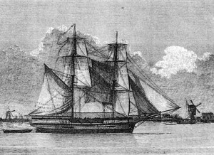
In November 1801 Governor King commissioned Acting Lieutenant Murray in command of His Majesty’s Armed Surveying Vessel, the “Lady Nelson,” to continue the exploration of the South Coast which Lieutenant Grant, the former Commander, had been unable to complete.
The “Lady Nelson” was a shallow draft ship of 60 tons especially designed by Captain Wm. Schanck (after whom Cape Schanck was named), built and fitted in England. An incredible voyage from England included the honour of being the first ship to journey through Bass Strait from west to east.
Courtesy Mitchell Library
Murray’s instructions demanded that particular attention be paid to the coast between Cape Schanck and Cape Albany Otway where a vast Bay had been reported by Grant. The ship carried four brass carriage guns and a crew of fifteen which included soldiers, sailors, a carpenter, cook, clerk, cabin boy and at least one naturalist whose duty it was to report back to English botanists on the beauty and usefulness of the various trees, plants, shrubs and grasses, and at the same time collect native seeds and specimens.
During this expedition Murray was frustrated by weather of which he says: “I shall only observe that I never experienced such a length of bad weather at any time of the year or in any country since I sailed the sea.” Gales alternated with thunderstorms and dead calms. They were perpetually loading water and starting out, only to return to Lady Nelson’s Point (Observation Point, Phillip Island) for shelter.
January 21
Finally in the early hours of January 21st, 1802, the launch of the “Lady Nelson” with the First Mate, Mr. Bowen, in charge of a crew of five, left Westernport and sailed around Point Nepean and into Port Philip, being the first white men to do so as far as the world holds record. They returned and reported on a “great and noble sheet of water” so once again preparations were made for the “Lady Nelson” herself to enter the Bay. However, there were more delays and it was not until 14th February that this gallant little ship cautiously rounded the Point.
February 15
. . . then southern shores of this noble harbour is bold high land . . . with stout trees of various kinds, and in some places falls nothing short in beauty and appearance from Greenwich Park . . . (London)
Murray spent 25 days in the bay naming Point Nepean, Point Palmer, and Point Murray which became successively known as Anchorage Point, Settlement Point and finally Point McArthur (known locally for many years as Duffy’s Point). He named Arthur’s Seat, Swan Island (now called Mud Island) and the Western Sister which was called Bowen Point after an affray with the natives there, when, in order to protect his crew, he was compelled to fire a “round of shot and grape” from the “Lady Nelson”. In addition to the duties laid down for the Commander of the “Lady Nelson” he spent much time in repairing his boats which were by this time in a very bad condition.
On 28th February, 1802, the first report of sailors being granted shore leave in Port Phillip appeared in the Log Book – “Gave some of the people liberty on shore.”
On 8th March he hoisted the Union Jack on Point King and took possession of Port King, later to be renamed Port Phillip, in the “name of His Sacred Majesty George III of Great Britain and Ireland.” This was the FIRST TIME THE UNION JACK WAS USED IN AUSTRALIA for the purpose of “taking possession,” the cross of St. Patrick of Ireland having only recently been added to the Cross of St. George of England and that of St. Andrew of Scotland thus forming the Union Jack.
A discrepancy exists between the date on the cairn erected to commemorate this event and that recorded here. This arises from the fact that in the Log Book of the “Lady Nelson” nautical time is observed when the date is changed at noon while in civil time it is changed at the following midnight.
(Extract from ‘The Peninsula Story’ Published by NHS 1992)
Matthew Flinders
Later, in April 1802 Matthew Flinders visited Port Phillip during his epic voyage.
Not being aware of Murray’s good fortune in January, Flinders treated Port Phillip as a fresh discovery, and examined its approaches with as much thoroughness as his resources would allow. At this time, however, the store of provisions was running low. The Investigator was forty weeks out from England, and re-equipment was fast becoming imperative. Her commander had felt the urgency of his needs before he reached Port Phillip. He had seriously considered whether he should not make for Sydney from King Island. “I determined, however, to run over to the high land we had seen on the north side of Bass Strait, and to trace as much of the coast from thence eastward as the state of the weather and our remaining provisions could possibly allow.”
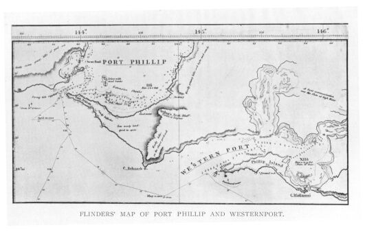
As related in the passage quoted above, Flinders at first thought he had reached Westernport, though the narrowness of the entrance did not correspond with Bass’s description of the harbour he had discovered four years previously. But Baudin had told him that he found no port or harbour of any kind between Westernport and Encounter Bay. Consequently, it was all the more astonishing to behold this great sheet of blue water broadening out to shores overlooked by high hills, and extending northward further than the eye could penetrate. It was not until the following day, April 27th, that he found he was not in the port which his friend had discovered in the whaleboat. Immediately after breakfast he rowed away from the ship in a boat, accompanied by Brown and Westall, to ascend the bluff mountain on the east side which Murray had named Arthur’s Seat. From the top he was able to survey the landscape at a height of a thousand feet; and then he saw the waters and islands of Westernport lying beneath him only a few miles further to the east, whilst, to his surprise, the curves of Port Phillip were seen to be so extensive “that even at this elevation its boundary to the northward could not be distinguished.”
